


The Manali – Leh cycling tour is one of the most scenic, challenging and popular mountain biking routes. You cover 475 km over 10 days going past many high passes – Rohtang (3900m), BaralachaLa (4800m), NakeeLa (4850m), LachungLa (4800m) and TanglangLa (5200m and the world’s second highest motorable road). The route is a mix of tarmac and unmetalled roads. Once you cross into Lahaul valley from Manali, you go past picturesque villages. However, after Darcha, it’s all wild country with no permanent villages till you cross Tanglang La closer to Leh. The only settlements you will come across are doksas or make-shift bed-and-breakfasts and off late, fixed campsites that have come up for the season. From alpine forests and meadows in Manali through deep valleys in Lahaul, and vast plains in Sarchu, you enter Ladakh – a land that offers every hue of orange, red, brown and ochre. Along the way your challenges include searing hot days, freezing nights and most importantly, high altitude.
ll riders will gather in Manali. Spend the evening getting acquainted with your fellow riders. Hang out at the dreamy little cafes across town, many of which have views of the idyllic mountains around.
Today we will do a gear check and last minute preparations.
We will do a ride to Solang valley to ensure we are all set for the long expedition. As the day winds down you can choose to go visit the hot water springs for a dip at Vashisht or Kalath. Overnight at Hotel.
The journey starts from the smooth roads of Manali. We take a series of hairpin bends to leave the Pine and Deodar forests surrounding Manali, cycle through the villages of Palchan, Kothi and Gulaba to reach the alpine meadows at Marhi – the base of the Rohtang Pass. Camp here for the night.
Cumulative Elevation Gain: 1600 m, Loss: 200 m
We start the day with a steep climb to the top of Rohtang Pass at nearly 4000m. The descent from the pass is the beginning of the mix of metalled and unmetalled roads. We follow the Chandra river here to reach the camping grounds at Sissu.
Cumulative Elevation Gain: 1600 m, Loss: 200 m
Today we cycle through Keylong – the biggest city in Lahaul and Tandi – the confluence of the Chandra and Bhaga rivers to form Chandrabhaga river which later becomes the Chenab. The gradient is low most of the day today. Camp at Jispa on the banks of the river.
Cumulative Elevation Gain: 1600 m, Loss: 200 m
We leave the inhabited parts of Lahaul behind to cycle through Darcha and start the climb to Patseo. Option to camp at Padseo or continue onward to Zing Zing Bar at the base of the Baralalcha La.
Cumulative Elevation Gain: 1200 m, Loss: 240 m
A long day today at high altitude. We start the day with a steep ascent to the top of Baralalchala at 5000m while crossing the emerald waters of Suraj Tal Lake on the way to the top. The path down is a welcome physical respite going through the dhabas at Bharatpur and then onward to the windy campsite of Sarchu for the night.
Cumulative Elevation Gain: 900 m, Loss: 900 m
We leave the vast camping site of Sarchu and begin the hairpin turns of the Gatta Loops to reach the Nakeela Pass at 5150m. Pang, our destination for the day is on the other side of the pass.
Cumulative Elevation Gain: 1450 m, Loss: 1250 m
A short ascent from Pang takes us to the extensive More Plains flatlands. The only sign of life in this Martian landscapes are the occasional nomadic Changpas tending to their herds of Yaks. One can also occasionally spot wild Tibetan asses – the Kiangs on the plains. We take Camp at Debring for the night.
Cumulative Elevation Gain: 540 m, Loss: 450 m
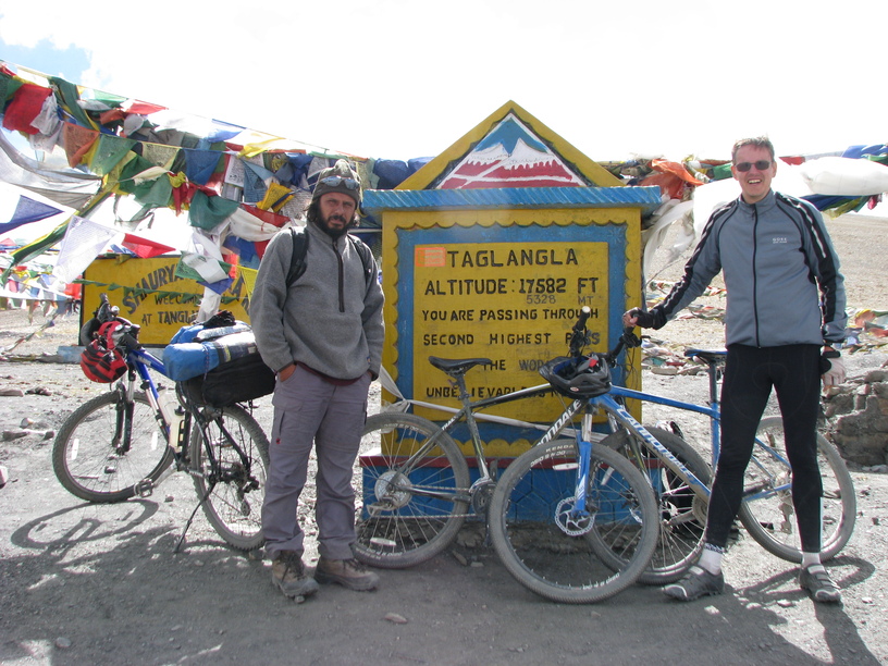
We start from our camp at Debring to the top of our highest pass on the trip – the Tanglang La at 5260m. On a clear day, the views from the top are expansive and overwhelming. We descend to get to the village of Rumtse and sort of back to civilisation. Our camp for the day is the village of Lato which is 10 Kms ahead of Rumtse.
Cumulative Elevation Gain: 1600 m, Loss: 200 m
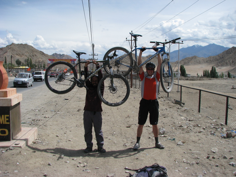
Today is the easiest day of the trip. We cycle the rest of the way to Leh town through mostly flat land. We cross several villages and Thiksey Monastery on our way to the town. Spend the night in a hotel in Leh.
The trip Ends and we drop you off to your Hotel in Leh.
Cumulative Elevation Gain: 1600 m, Loss: 200 m
Clothing:
– Good quality waterproof jacket
– Waterproof trousers
– Balaclava (thick fleece)
– Sun hat
– Cycle mitts
– Warm gloves – mountaineering gloves (waterproof outer, fleece inner) are good.
– Mid-weight fleece top
– Cycling tights (looser, “trackster” fit rather skin-tight lycra),
– Shorts
– Long sleeved shirt
– Travel trousers
– 2 wicking tee-shirts (synthetic or merino wool)
– Cotton tee-shirt for around town
– Long sleeved thermal top
– Thermal long johns
– 2-3 pairs underwear
– 2-3 pairs of standard socks
– 1 pair warm sock
Footwear:
– Cycling shoes, e.g. SPD’s, if applicable (bring spare cleats)
– Trekking shoes and climbing shoes
– Flip-flops, Crocs or Sandals to wear around camp.
Pack:
– Main bag – soft shell duffle bag to be kept in the logistics vehicle.
– Day Pack 15 – 20 lts – You will use this to carry your camera, water bottle, Trail layers, trail food etc.
Accessories:
– A bike helmet
– Dark glasses (the sun is very strong),
– Camera
– Toiletries – Sunscreen SPF 40+, Moisturizer, Lip balm, Soap, Toilet paper
– Repair Kit (needle and thread).
– Headlamp/ Torch.
– Water Bottle- Ideally keep two bottles 1 litre each.
– Plastic Packing covers.
Documents:
– A couple of spare passport photos photocopies of key documents. e.g., passport (data and visa pages),
– Travel insurance policy
The Manali – Leh cycling tour is one of the most scenic, challenging and popular mountain biking routes. You cover 475 km over 10 days going past many high passes – Rohtang (3900m), BaralachaLa (4800m), NakeeLa (4850m), LachungLa (4800m) and TanglangLa (5200m and the world’s second highest motorable road). The route is a mix of tarmac and unmetalled roads. Once you cross into Lahaul valley from Manali, you go past picturesque villages. However, after Darcha, it’s all wild country with no permanent villages till you cross Tanglang La closer to Leh. The only settlements you will come across are doksas or make-shift bed-and-breakfasts and off late, fixed campsites that have come up for the season. From alpine forests and meadows in Manali through deep valleys in Lahaul, and vast plains in Sarchu, you enter Ladakh – a land that offers every hue of orange, red, brown and ochre. Along the way your challenges include searing hot days, freezing nights and most importantly, high altitude.
ll riders will gather in Manali. Spend the evening getting acquainted with your fellow riders. Hang out at the dreamy little cafes across town, many of which have views of the idyllic mountains around.
Today we will do a gear check and last minute preparations.
We will do a ride to Solang valley to ensure we are all set for the long expedition. As the day winds down you can choose to go visit the hot water springs for a dip at Vashisht or Kalath. Overnight at Hotel.
The journey starts from the smooth roads of Manali. We take a series of hairpin bends to leave the Pine and Deodar forests surrounding Manali, cycle through the villages of Palchan, Kothi and Gulaba to reach the alpine meadows at Marhi – the base of the Rohtang Pass. Camp here for the night.
Cumulative Elevation Gain: 1600 m, Loss: 200 m
We start the day with a steep climb to the top of Rohtang Pass at nearly 4000m. The descent from the pass is the beginning of the mix of metalled and unmetalled roads. We follow the Chandra river here to reach the camping grounds at Sissu.
Cumulative Elevation Gain: 1600 m, Loss: 200 m
Today we cycle through Keylong – the biggest city in Lahaul and Tandi – the confluence of the Chandra and Bhaga rivers to form Chandrabhaga river which later becomes the Chenab. The gradient is low most of the day today. Camp at Jispa on the banks of the river.
Cumulative Elevation Gain: 1600 m, Loss: 200 m
We leave the inhabited parts of Lahaul behind to cycle through Darcha and start the climb to Patseo. Option to camp at Padseo or continue onward to Zing Zing Bar at the base of the Baralalcha La.
Cumulative Elevation Gain: 1200 m, Loss: 240 m
A long day today at high altitude. We start the day with a steep ascent to the top of Baralalchala at 5000m while crossing the emerald waters of Suraj Tal Lake on the way to the top. The path down is a welcome physical respite going through the dhabas at Bharatpur and then onward to the windy campsite of Sarchu for the night.
Cumulative Elevation Gain: 900 m, Loss: 900 m
We leave the vast camping site of Sarchu and begin the hairpin turns of the Gatta Loops to reach the Nakeela Pass at 5150m. Pang, our destination for the day is on the other side of the pass.
Cumulative Elevation Gain: 1450 m, Loss: 1250 m
A short ascent from Pang takes us to the extensive More Plains flatlands. The only sign of life in this Martian landscapes are the occasional nomadic Changpas tending to their herds of Yaks. One can also occasionally spot wild Tibetan asses – the Kiangs on the plains. We take Camp at Debring for the night.
Cumulative Elevation Gain: 540 m, Loss: 450 m
We start from our camp at Debring to the top of our highest pass on the trip – the Tanglang La at 5260m. On a clear day, the views from the top are expansive and overwhelming. We descend to get to the village of Rumtse and sort of back to civilisation. Our camp for the day is the village of Lato which is 10 Kms ahead of Rumtse.
Cumulative Elevation Gain: 1600 m, Loss: 200 m
Today is the easiest day of the trip. We cycle the rest of the way to Leh town through mostly flat land. We cross several villages and Thiksey Monastery on our way to the town. Spend the night in a hotel in Leh.
The trip Ends and we drop you off to your Hotel in Leh.
Cumulative Elevation Gain: 1600 m, Loss: 200 m
Clothing:
– Good quality waterproof jacket
– Waterproof trousers
– Balaclava (thick fleece)
– Sun hat
– Cycle mitts
– Warm gloves – mountaineering gloves (waterproof outer, fleece inner) are good.
– Mid-weight fleece top
– Cycling tights (looser, “trackster” fit rather skin-tight lycra),
– Shorts
– Long sleeved shirt
– Travel trousers
– 2 wicking tee-shirts (synthetic or merino wool)
– Cotton tee-shirt for around town
– Long sleeved thermal top
– Thermal long johns
– 2-3 pairs underwear
– 2-3 pairs of standard socks
– 1 pair warm sock
Footwear:
– Cycling shoes, e.g. SPD’s, if applicable (bring spare cleats)
– Trekking shoes and climbing shoes
– Flip-flops, Crocs or Sandals to wear around camp.
Pack:
– Main bag – soft shell duffle bag to be kept in the logistics vehicle.
– Day Pack 15 – 20 lts – You will use this to carry your camera, water bottle, Trail layers, trail food etc.
Accessories:
– A bike helmet
– Dark glasses (the sun is very strong),
– Camera
– Toiletries – Sunscreen SPF 40+, Moisturizer, Lip balm, Soap, Toilet paper
– Repair Kit (needle and thread).
– Headlamp/ Torch.
– Water Bottle- Ideally keep two bottles 1 litre each.
– Plastic Packing covers.
Documents:
– A couple of spare passport photos photocopies of key documents. e.g., passport (data and visa pages),
– Travel insurance policy